


If you ever happen to watch/hear the WA weather, you will see quite a dramatic drop in temperature between Exmouth and Carnarvon, and again between Carnarvon and Geraldton. Exmouth is on roughly the same latitude as Alice Springs and Rockhampton, whereas Geraldton is about level with the Gold Coast. We were certainly beginning to notice the difference - being a lot more reluctant to get the bathers on and to sit outside after dark. Geraldton was also very windy (living up to its reputation) with this nasty southerly coming up every day in the early afternoon and blowing right through you. We arrived early-ish on Monday (13 Sept) and after squeezing into our spot in the van park we went for a drive south through Greenough ("Grenuff"), where we found the classic Geraldton leaning tree, a surf beach called Flat Rocks (which could have been called Flat Sea on that day) and the historical settlement of Greenough, which dates back to the mid-1800s. We did a tour around the eleven or so historic buildings, including the one-room school built in 1863, the courthouse/gaol, two churches (one Catholic one Anglican), a convent and a community hall. Obviously a very devout community! It was a lovely set-up, all contained in a big (fenced) field full of sweet-smelling cut grass (hay), where you could wander up a central road and into each building at your own pace, and the children were each provided with a worksheet with pictures of items they had to find along the way. This maintained their enthusiasm and ensured we checked out every single room.
On Tuesday we spent the day looking around Geraldton (well - Andrew found a surf beach in the morning, so he missed some of the sightseeing) and finished up at the museum (nice logo - the mUSEm with a magnifying glass around "USE") where the girls had another worksheet to do (we parents felt very virtuous!) and we found some fascinating information about historical shipwrecks along the mid-coast of WA - in particular dutch cargo ships travelling from Europe to the Dutch East Indies in the 1600s. They were definitely the first Europeans to set foot on Australian soil - long before James Cook - and how incredible to have been sailing regularly along this route 350 years ago! No wonder there were so many shipwrecks. Much more recently, the HMAS Sydney was lost somewhere between Shark Bay and Geraldton during WWII, with the loss of 645 lives, and Geraldton has a huge memorial to it on a hill overlooking the town. This puzzled me, as Geraldton doesn't really have much more of a claim to the ship than any other town in Australia (okay it visited here a couple of times) but it seems that they had a wealthy rotary club and managed to get themselves organised! (There is also a "cairn" on a dirt road between Quobba Point and Red Bluff, pointing out to sea in the general area that the ship was believed to have sunk.) Now that the wreck has actually been found, more or less directly out from Shark Bay, I suspect there is likely to be a shift in the tourism focus to that spot, but of course all these memorials pre-date that discovery in 2008.
So that was our whirlwind tour of Geraldton. On the way out, heading south again, we stopped at the Pioneer Museum and cemetery (also in Greenough). The museum was a cottage that used to be owned by John Maley - one of the leading families of the district, set up pretty much as it would have been from the mid-1800s. The family had 14 children, all of whom survived to adulthood and the mother had time to teach the girls to play the piano!!! I suppose having a maid and a cook helped, but still. I was humbled!
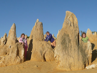
From Geraldton we went to Jurien Bay for one night, in order to visit the Pinnacles Desert a bit further south, near Cervantes. This we did on the day we arrived, which meant we saw it in the late afternoon and stayed there to watch the sun set. That was pretty special. It's a massive place - much bigger than I expected (and Kendall thought there were only three pinnacles altogether). There must have been 20,000 or more of them. All used to be under the sea, and the stuff in between has simply eroded away since the water receded. It's amazing what you can do with a little sand, water and wind, isn't it?
On the way south in the morning, we went via the Mount Lesueur National Park, which has a one-way tourist drive through the most beautiful wildflowers and scenery. It was just sensational. The 18km took us about two hours (and 200 photos!).
After Jurien Bay, we were headed for Mandurah, about 60km south of Perth. We had chosen this stop because we have a friend living there, and we'd decided to skip the "big city" because that could always be visited another time. However, we thought we'd be adventurous and drive through the city (with the caravan) so that the girls could at least get a general sense of it. This was a mistake! We connected up the GPS and we got into a terrible argument with her over a right turn and ended up going round in circles in the centre of Perth just before rush hour - finally finding our way out by ignoring her instructions and "recalculations". Then we ended up caught in rush hour traffic on the (wonderful) freeway heading south, made the mistake of listening to the GPS again when she took us off the freeway 30km too early (not knowing that it had been extended all the way to Mandurah) and finally arrived in Mandurah just after dark. At this point we discovered that the fridge had opened and a very sticky jar of chutney had spilt on the floor and over EVERYTHING; plus the power on the site wasn't working so I was cleaning up by torchlight while Andrew chased up the manager..... Oh well - things can't be perfect all the time!
Our day in Mandurah was another day of wandering around sightseeing. There was no surf at all, but the weather was perfect and we had coffee/ice-cream on the boardwalk over the lake in the middle of town, watching the pelicans and dolphins in the water. Mandurah is built around the Peel Inlet - and all these canals that run off of it, before it goes out to sea. The town also extends along a narrow spit of land, with the inland waterways on one side and the Indian Ocean on the other. Surf and snorkelling beaches all the way down the west side, and boating and fishing, plus walking and bike trails everywhere. And a fast train straight into Perth in under an hour. I could definitely live here - that's if I could afford the house prices!
By now we'd travelled another 500km or so due south, and the temperature was certainly dropping. We're still north of Adelaide (about level with Port Augusta) but only just! And while we have been extremely lucky in avoiding almost any rain at all, it's not really all that lucky for WA that they've had another very dry winter. Water restrictions persist and we're not allowed to clean our poor caravan anywhere. And didn't our car use to be white?
Captions for pictures
- The classic leaning tree of Geraldton
- Kendall in the dock; judge Tahlia presiding
- Geraldton docks overlook the central Town Beach
- HMAS Sydney memorial. Look closely and you can see it is made up of the shapes of 645 seagulls: one for each life lost
- Andrew giving the girls a lesson in the operation of a wheel band-stretcher at the Pioneer Museum, Greenough
- The Pinnacles
- And again
- There are just so MANY of them!
- An unusual pinnacle formation caused by extreme cold and oversized covering
- Wildflowers in Mt Lesueur NP
- Mandurah across the Peel Inlet lake
- Falcon Bay beach and lovely snorkelling pool (Mandurah)
Had to laugh at your recount of the 'argument' with the GPS lady... Great to read you are still retaining your excellent sense of humour Sandy!! Miss you guys and looking forward to your return back to Rosella Close. Liz xxx
ReplyDelete